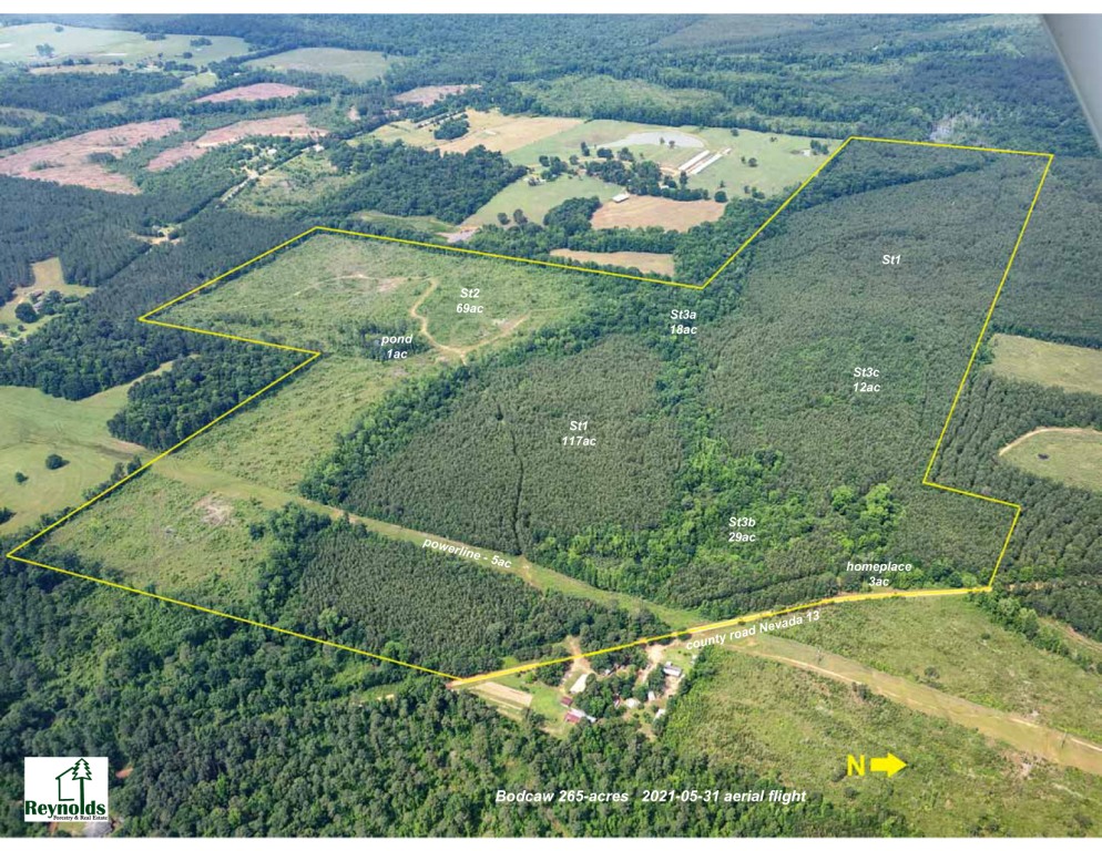
Reynolds Forestry Consulting

& Real Estate, PLLC

a small company doing big things...

Contents
Click topic below for viewing
HOME
2012 Forestry Conference
Land Sales
Timber Sales
Home Sales
Hunting Leases
Office Location
Contact RFC
Would you like to receive emails for land or timber sales: Click here

Information about:

Timberland Management
Site Preparation
GIS
Custom Designed Maps
Pictures
Mechanical Site Prep
Resort Marketing
Forestry Articles

Community

Community Projects
Timber Talk Radio Show
Affiliations & Links
Featured Photograph

8-year old loblolly pine plantation at Reynolds' Farm after January 2011 snow with

average dbh 7 inches and average height 30 feet


Click to send e-mail

Our site is best
viewed using Internet
Explorer 4.0 or greater.
If you don't have it... 
Upgrade now.

Get Internet Explorer 5.0

walker

Links

If you are interested in mapping, cartography, GIS, GPS, satellite imagery or any related field, please browse though the links below. 

GIS/Mapping Links

Satellite / Aerial Imagery

What is GIS? Terraserver - (digital imagery for USA)
United States Geological Survey (USGS) Satellite Imagery
GIS World Magazine National Imagery and Mapping Agency (NIMA)
Starting Points for GIS/Cartography
Remote Sensing and GIS Resources
GIS FAQ by US Census Bureau 
Association for Geographical Info GIS Dictionary
Free GIS Data GPS Links
Spatial Analysis Lab - U of A, Monticello
(click the "Natural State Digital Database link)
Corvallis Microtechnology
GIS Data Depot Trimble GPS Tutorial
Navtech Page of GPS Links
Global Positioning System Overview
Forestry Links
See RFC affiliation & links page